
Most complete Earth map published (Japan)
BBC NEWS | Science & Environment | Most complete Earth map published.
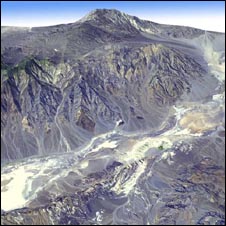
The most complete terrain map of the Earth’s surface has been published.
The data, comprising 1.3 million images, come from a collaboration between the US space agency Nasa and the Japanese trade ministry.
The images were taken by Japan’s Advanced Spaceborne Thermal Emission and Reflection Radiometer (Aster) aboard the Terra satellite.
Categories: tehsuki import
Recent Comments